A camera system for boring machines used in tunnel construction, such as those drilling the Brenner Base Tunnel in the Austrian Alps, has been developed by an Austrian university.
The camera, the result of the TBMonitor R&D project at the Institute for Subsurface Engineering of Montanuniversität in Leoben, Austria, is being field-tested in a hard rock tunnel boring machine (TBM) working on the Brenner Base Tunnel. The vision system was built in collaboration with Geodata and Stemmer Imaging, using cameras from Allied Vision.
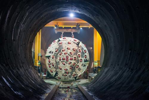
A boring machine at the Brenner Base Tunnel. Credit: Galleria di Base del Brennero – Brenner Basistunnel BBT SE
The camera provides high resolution images and colour-coded relief presentations of the rock face being drilled. Mineral composition, spatial position of stratifications, and depth of cavities can all be determined, all of which gives a structural assessment of the wall and verifies whether geological models are correct.
Approximately 70 per cent of the work on the Brenner Base Tunnel is carried out by six TBMs. In conventional tunnelling, a geologist will map the face of the tunnel, but a TBM has a cutter head that obstructs the view of the rock.
The TBMonitor camera unit is designed to be lightweight and is mounted in the cutting disc housings. The unit encompasses a rugged camera that can operate in extreme environments and fluctuating lighting conditions, together with a 5mm lens with fixed focal length. Allied Vision’s Prosilica GT2000 GigE Vision camera with a 2.2 megapixel CMOS sensor offers precise iris lens control, meaning the aperture size can be fixed to optimise the depth of field – ranging from 20cm to 200cm – exposure and gain without the need for additional control elements. Equipped with Power-over-Ethernet functionality (PoE), the camera can be operated with a single cable for power supply and data transfer, which simplifies integrating the system into the cutter head.
The LED ring used gives more than 10,000 lumen and pulses at 4ms to remove motion blur. The camera is set to continuous auto-exposure within a region of interest, which updates the exposure time for each image in order to ensure equal illumination and avoid over or underexposure for different sections of the face.
‘Digital imaging of the face leads to a more objective geological mapping being an incontrovertible basis of geological assessment,’ said Robert Wenighofer, project assistant at the Institute of Subsurface Engineering of Montanuniversität Leoben.
‘After more than a year of applying the camera system, photogrammetric processing has proven to be an appropriate means of documenting the face even in the harsh environment of a hard rock TBM drive. The camera system provides high resolution orthophotos and relief presentations of the face representing an objective basis for geological mapping,’ he added.
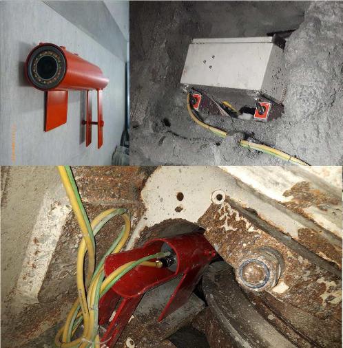
Above left: camera unit; below: camera unit mounted in disc housing; above right: control unit. Credit: Institute for Subsurface Engineering of Montanuniversität in Leoben, Austria
The control unit has interfaces for several cameras that can be operated in parallel to accelerate the measuring campaign if desired. The camera and the control unit are connected via a Category 7 cable, allowing Ethernet data transmission at 10Gb/s.
The camera control running on the PC is based on Allied Vision’s software development kit Vimba. It triggers the camera in a fixed rate of 2 images per second providing a sufficient overlap and surplus of images. The control unit is set to initiate image recording automatically after the PC has booted. In order to avoid interacting with camera control as far as possible in the harsh conditions of the cutter head, no direct input to the system is necessary – the PC can be remotely controlled with a smartphone.
The control unit is equipped with an inclination sensor establishing a common coordinate system for all images taken in one measurement campaign. Each image is assigned an angular value retrieved from the inclination sensor when the camera signals an image has been taken. The inclination angle and the known relative position of the disc housing mean the absolute position of the camera in the 3D reference coordinate system of the cutter head can be determined, which provides essential information for photogrammetric processing.
A full-face camera campaign can consist of more than a thousand overlapping images. The images are processed by photogrammetry to create a 3D model of the rock face. PhotoScan software from Agisoft was chosen for this task.
At the end of a highly automated photogrammetric workflow, not only a dense 3D reconstruction of the full face is computed, a high resolution orthophoto – distortion-free, true-to-scale representation of the surface – is created, showing equal illumination covering break-outs and stable face areas, and presenting details that cannot be seen behind the cutter head. A colour-coded relief presentation of the rock face is also generated based on this image.
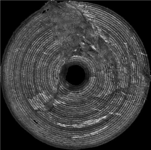
Orthophoto of the full face showing equal illumination covering break-outs (upper part) and stable face areas. Credit: Institute for Subsurface Engineering of Montanuniversität in Leoben, Austria