
This year major US pipeline operator Energy Transfer will be using fellow US startup Orbital Sidekick’s (OSK’s) new GHOSt satellite constellation to detect gas and hydrocarbon leaks via hyperspectral imaging.
The constellation – scheduled for launch between late 2022 and early 2023 – consists of six technically identical hyperspectral imaging microsatellites.
It is designed to offer frequent monitoring of pipeline assets to the global oil and gas industry, helping it meet compliance and regulatory obligations.
Hydrocarbon or gas leaks are some of the world’s most pressing energy issues.
In the US alone 6,000 pipeline incidents between 2002-2021 resulted in over $11 billion in damages.
Traditionally such leaks have been detected using small aircraft and pilots looking out the window, which relies on a trained eye rather than sensors or other technologies.
OSK’s GHOSt constellation will instead be capable of accomplishing what a pilot can, but much more quickly, objectively and with higher accuracy.
“Space-based hyperspectral intelligence basically breaks up the spectrum of light so it’s possible to see what’s happening at a chemical level without needing an aircraft,” explained Kaushik Bangalore, vice president of payload engineering at OSK.
The hyperspectral data – captured in over 500 bands between 400-2,500nm – will be processed and analysed in real time using NVIDIA’s Jetson AGX Xavier edge AI platform. Then, insights – such as the type of leak, its size, urgency and location – will be viewable on a screen by users of OSK’s SIGMA (Spectral Intelligence Global Monitoring Application) Monitor platform.
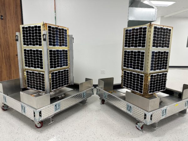
OSK's GHOSt satellites are equipped with hyperspectral imaging sensors to monitor gas pipelines from orbit (Image: OSK)
“We’re taking hyperspectral intelligence to the finest commercial resolution that the world has ever seen to make the Earth a more sustainable place,” Bangalore continued. “The biggest challenge with hyperspectral imagery is dealing with huge amounts of data, which can be up to 400x the size of 2D visual data. NVIDIA technology helps process this data in real time.”
The edge AI platform, along with the NVIDIA’s Python software toolkits, have sped up OSK’s analysis by five times, enhancing its ability to detect and recognise anomalies from space before projecting the data back to Earth. GHOSt will perform 15 sun-synchronous orbits per day, with all the captured data in each orbit being processed within that same orbit, enabling continuous data capture.