Remote sensing has proven to be an invaluable tool in obtaining data to study natural disasters.
Although only launched in April, the European Space Agency’s Sentinel-1 satellite has already assisted in the emergency response to May’s Balkan floods that resulted in the displacement of hundreds of thousands of people. And, NASA’s Landsat satellite has recently been helping communities in America to determine their flood risk.
But as sensor technology is getting smaller, small satellites are starting to move into the commercial sector, opening up more ways in which researchers and companies can analyse natural disasters.
Since the launch of Landsat 1 in 1972, the NASA’s Landsat satellite has collected spectral information from Earth, providing the longest continuous global record of its surface. Landsat 8, the newest satellite in the joint NASA and US Geological Survey (USGP) programme, was launched in February 2013, and collects more than 400 images per day. Over five million new and archived images are available to the public, offering scientists the ability to carry out in-depth analyses of changes to the Earth’s landscape, and the data has been put to various uses studying natural disasters.
‘Now, people are going through the Landsat data archive which goes back to 1972, and can stack images from year-to-year, and from season to season. The computer is used to track the change of those images over time going back 40 years,’ explained Dr James Irons, deputy director for hydrospheric and biospheric sciences at the NASA Goddard Space Flight Centre.
Recently, the Landsat data has helped communities in the United States to monitor their flood risk. The Federal Emergency Management Agency (FEMA) has been analysing Landsat images showing expanding cities over a period of 25 years, to investigate how urbanisation will affect the likelihood or intensity of damage in the event of flood. ‘If you identify areas where urban change is accelerating, there are consequences,’ said Zack Roehr, a senior spatial analyst with FEMA subcontractor Dewberry.
‘The ground is no longer able to hold water, which means local flooding sources are going to receive more of that water,’ Roehr said. ‘The flooding characteristics are going to change.’
NASA’s Irons added: ‘Whether it is a natural disaster or a man-made disaster, or just a small evolution of change, we have images collected before and after, and we preserve those images in the archive exactly for that purpose,’ he said. ‘So, if somebody wants to know the effect of a hurricane on the ecosystems of Louisiana, for example, in the archive there are images collected before hurricane Katrina, and images after Katrina. So people can do analyses of the impact of the hurricane on wetland, or on transportation, or through the Mississippi River, or on the extent of the flooding cause by the hurricane.’
And, the data not only allows researchers to study the effects of change, but present evidence to responsible officials. ‘Our programme in general is to allow people to provide information to policy-makers, or managers who can affect changes to policy or to management practices to hopefully improve the situation, whether locally or globally,’ Irons noted.
On board the Landsat 8 satellite, there are two push-broom sensors; the Operational Land Imager (OLI), and the Thermal Infrared Sensor (TIRS). These instruments do not use oscillating mirrors to sweep across the field of view, but a long array of detectors arranged perpendicular to the flight direction of the satellite. The telescope of the OLI and TIRS first directs the field of view across a strip of ground, which at any one moment is an area 185km wide. ‘It collects data across that swath, reads out the detectors’ signal, and then it flies forward − the shutter stays open, the detectors are read out, but the detectors view another line across that swathe,’ explained Irons. ‘As the satellite moves forward down the orbit, you continue to build up a two dimensional image.’
The Landsat-8 is the first Landsat satellite to use the push-broom approach, which has a number of advantages, such as providing a higher level of sensitivity. ‘The sensors can be more sensitive to the light that reflects or emits from the Earth’s surface, because it improves the signal-to-noise ratio,’ said Irons. ‘If we increase the signal-to-noise ratio, then you have a more sensitive signal or recording of the light.’
An increased signal-to-noise ratio on the Landsat 8 has also allowed for a higher level of sensitivity than previous satellites, including the Landsat 7 − which is still in operation −that has an Enhanced Thematic Mapper (ETM+ sensor) on board. ‘The data from the Thematic Mappers were digitised to 8 bits − in other words there were 256 levels of light that we could distinguish in TM data,’ Irons explained. ‘The data from the Landsat 8 sensors were quantised to 12 bits, so we are able to distinguish 4,096 levels of light intensity using the data from the OLI and the TIRS sensors. That makes the observations more sensitive to change across the land surface and change over time.’
The data collected from the sensors is then interpreted to create an image showing the composition of the Earth’s surface. ‘It is the distribution of the light intensities across those multiple wavelengths that allow us to analyse those images to identify different features on the surface of the Earth,’ Irons said. ‘We can write algorithms for computers to go through billions of pixels and recognise surface features based on the distribution of the light intensities across those multiple wavelengths.’
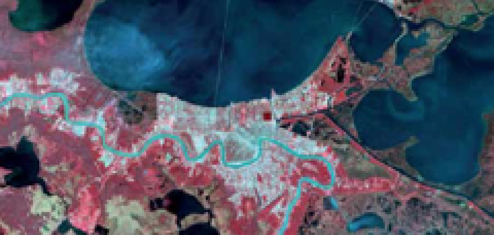
Another satellite helping to monitor the effects of flooding is the European Space Agency’s (ESA) Sentinel-1A satellite, which has provided data for mapping the floods that caused widespread destruction in Bosnia and Herzegovina in May. The satellite was launched in April, and is the first in a fleet of Sentinel satellites developed for Europe’s Copernicus environmental monitoring programme.
The imaging radar on the satellite is still being calibrated, however, this Balkan coverage is an early example of the kind of operational data the mission will provide for emergency response. Images acquired before and after floods offer immediate information on the extent of inundation and support assessments of property and environmental damage.
Once operational, it is expected that the Sentinel-1 will advance the way satellites are used in risk assessment management and emergency response, as it is capable of transmitting large amounts of radar data in a systematic fashion.
Never miss a frame
In order to continue the long term Landsat data record, NASA and the US Geological Survey are currently working on a Sustained Land Imaging (SLI) programme, to establish a sustainable satellite system that will provide continuous Landsat-quality measurements while minimising the risk of gaps in data collection. ‘In the past, Landsat satellites have been developed one or two at a time, and then the US has waited until it is often too late to plan for the next Landsat satellite – and there has been a lot of luck involved in avoiding a data gap and not having repeated measurements,’ explained Irons.
An SLI Architecture Study Team was set up to study what technology could provide the best balance of measurement capability, data continuity, and cost. ‘This team was tasked to evaluate many different options for sustaining land imaging in the future,’ Irons said.
The results of fiscal year 2014 architecture studies (http://sustainablelandimaging.gsfc.nasa.gov/) indicated that efficiencies can be gained by moving toward smaller satellites, or ‘smallsats’, to take advantage of lower-cost and speedier launches. ‘There is now a whole taxonomy of satellites with the idea of trying to build smaller satellites, because then building and launching those satellites would reduce cost,’ Irons said.
The team are looking to use technology which will already be commercial, to minimise risk, time and cost, however it has proven to be difficult to forecast technological trends in this field. ‘Part of the challenge presented to this architectural study team was to look at different points in the future where these new technologies might be sufficiently well developed and demonstrated to incorporate into a Sustained Land Imaging programme, and that is like looking into a crystal ball and trying to predict the future,’ Irons said.
‘We are looking for technologies that are well developed and demonstrated; this is not a technology development or a technology demonstration programme. We are looking for something that has high technical readiness.’
Small-sats
The industry is already seeing a trend towards low cost small satellites for remote sensing and disaster management. ‘It is rare that countries or companies can afford huge traditional satellite launches like they used to, so there is a movement towards small-sat launches,’ said David Bannon, CEO of Headwall Photonics.
‘The commercialisation of the space industry is really interesting, and that is why so much of our design and development efforts are devoted to that kind of market. Traditional approaches to instrument development and deployment are no longer viable given the focus on cost containment and schedule predictability.’
The movement towards low cost commercial launches has been partly driven by the advances made in sensor technology for remote sensing and hyperspectral analysis, according to Bannon: ‘You have an established infrastructure of satellite companies who were primarily focused on military business. But with a focus on earth monitoring and the development of advanced sensor technology, many companies now understand that the capabilities and competences learnt as a military defence contractor can be very easily moved over into the commercial remote sensing world,’ he said.
And, competition between traditional satellite companies and the emergence of a new breed of space data companies has also driven the market towards the use of small satellites, Brannon added: ‘A whole tier of exciting new companies are competing with low-cost satellite launches against these traditional providers,’ he noted. ‘For example, companies such as Planet X and SkyBox are developing these smallsat launch capabilities that effectively make the whole concept of commercial remote sensing from a satellite a lot more cost effective. Sensor technologies such as hyperspectral imaging are critical to establish earth monitoring capability for disaster monitoring, environmental analysis, and climate change studies.’
But as satellites are becoming smaller, so must the imaging equipment. ‘The challenge is getting the instruments down to a size that would fit on the smaller satellites,’ said NASA’s Irons.
Headwall Photonics produces hyperspectral systems for both commercial satellite providers and government programmes involved in remote sensing from space, including NASA and the ESA. Its sensors are designed based on a reflective concentric approach, with advanced aberration-corrected optics that yield a large flight swathe. The instrument can thus be smaller and more robust. ‘We are able to shrink the size of the sensors, and they fit really well into this category of smallsat requirements without sacrificing payload performance,’ said Bannon.
For small satellites, Headwall has a sensor package with co-registered pixels: a visible near infrared (380-1,000nm) sensor and a shortwave near infrared (950-2,500nm) sensor for detection of objects such as minerals which yield spectral signatures in the SWIR range. ‘We deploy sensors that cover a full spectral range of 380-2,500nm, so people are able to utilise spectral data for that broad spectral region; this is a requirement for agriculture and geosciences applications which offer viability as commercial data products,’ explained Bannon.
Unmanned aerial vehicles
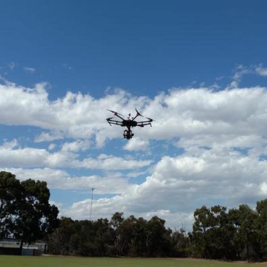
Another type of platform that is being used more in the commercial sector to monitor natural disasters is Unmanned Aerial Vehicles (UAVs). ‘UAVs are perfect flight vehicles for surveying and assessing disaster areas,’ said Bannon. ‘[UAVs] represent an incredibly cost effective solution which allows researchers to inexpensively, quickly, and tactically assign a sensor resource to an area to capture spectral data within a scene.’
According to Bannon, there has been a high demand for all-in-one solutions for UAVs, and Headwall Photonics has moved into this area. ‘We have been requested by customers, and what we also see in the market, is the need for an integrated sensing solution,’ he said. ‘To focus on providing a highly integrated sensor platform, Headwall expanded our solution set beyond the hyperspectral sensor; we sell the UAV integrated with complementary sensor technologies to make it run. Our customers don’t have the time or the expertise to build cost efficient platforms like that; they are focused on the application and the derived data products.’
And, because Headwall also designs and manufactures the diffraction gratings, each hyperspectral imager can be optimised for the specific application, whether it is to track forest fires or assess oil spills. ‘We peak the diffraction efficiency of the optics somewhere in the diffraction range where the customer’s application requires the highest signal, but we also do it relative to the quantum efficiency of the electronic module,’ explained Bannon. ‘So there are two factors: the optics module has a diffraction efficiency associated with it, and the electronics module has a quantum efficiency associated with it. And what we do is optimise those two curves to provide the most balanced performance across that spectral range.’
Hyperspectral imagers are deployed on UAVs to track and monitor forest fires, to help fire services decipher the best way in which to distribute their resources. ‘If you are looking at a forest fire, which would be a mid-wave [infrared] spectral range application, we would provide our customers with a mid-wave [infrared] sensor. The users capture the hyperspectral data, quickly process the data, and generate fire priority reports that they would give to the forestry service teams on the ground.’
The movement towards smaller, lower cost remote sensing systems is set to continue.